logo Vind Nå Kom igang Kontakt info Innstillinger

Rye sørtrøndelag paragliding spot

SVV

Trøndelag - Melhus -
(Data fra flightlog.org - statistikk siste flyture)

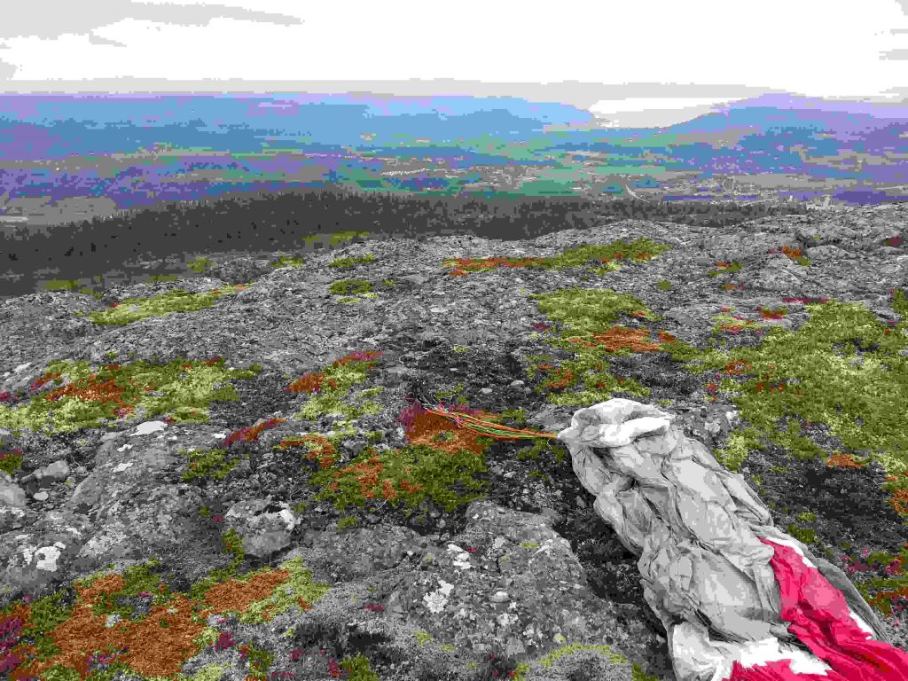
There is a trail from Rye to this takeoff, but usually you would fly up here from Rye. If you come from Vassfjellet this might be a possibility to start. You will need some westerly wind and lift to get over the little Ridge towards vest. There is also a possibility to fly out the vally alång the creek towards north-west and around Furuåsen.

580 meters asl Høydeforskjell 560 meters

Kjenner du til denne spotten og har lyst å hjelpe Vindnå.no med oppdatert informasjon, sende inn dine endringsforslag her.

Bilde fra flightlog.org.

Kart

Værvarsel fra yr.no

 22:00  23:00  00:00  01:00  02:00  03:00  04:00  05:00  06:00  07:00  08:00  09:00  10:00  11:00  12:00  13:00  14:00  15:00  16:00  17:00 
yr.no
nedbør00000000000000000000
m/s 5.25.55.965.85.455.7665.85.86.16.86.56.87.488.38.4
S
(159)

(157)
S
(158)
S
(159)
S
(160)
S
(159)
S
(158)
S
(158)
S
(160)
S
(159)
S
(161)
S
(160)
S
(160)
S
(161)
S
(163)
S
(167)
S
(165)
S
(168)
S
(170)
S
(172)
C4.64.33.93.73.53.33.12.92.62.53.24.25.97.188.898.78.37.8

Live værdata E6 Kvål 2.0 km unna.

 22:00  21:50  21:40  21:30  21:20  21:10  21:00  20:50  20:40  20:30  20:20  20:10  20:00  19:00  18:00  17:00  16:00  15:00  14:00  13:00 
m/s 3.344.75.75.33.12.53.23.94.95.14.94.74.35.64.45.667.37.8
max 5.77.58.47.68.55.14.15.36.36.57.27.16.76.57.87.199.510.411.3
S
(174)
S
(173)
S
(164)
S
(160)
S
(163)
S
(176)
S
(188)
S
(172)
S
(164)

(156)

(152)

(149)

(150)

(151)

(154)
S
(169)
S
(183)
S
(164)

(154)

(155)
C11.111.211.311.611.511.410.911.411.612.412.312.612.612.813.513.713.813.612.812.3

Live værdata E39 Øysand 8.2 km unna.

 22:00  21:50  21:40  21:30  21:20  21:10  21:00  20:50  20:40  20:30  20:20  20:10  20:00  19:00  18:00  17:00  16:00  15:00  14:00  13:00 
m/s 1.721.10.80.81.31.71.91.41.21.51.30.51.81.92.433.644.3
max 3.43.52.62.42.42.52.83.43.42.22.82.31.43.13.44.65.86.57.17.6

(117)
Ø
(108)
Ø
(105)
S
(166)

(149)
V
(261)
SV
(229)
S
(182)
S
(184)
SV
(212)
S
(195)
V
(248)
SV
(227)
S
(171)
Ø
(108)
Ø
(102)
Ø
(91)
Ø
(81)
Ø
(87)
Ø
(82)
C10.610.89.99.99.599.710.510.610.210.3109.511.713.413.713.913.613.312.6

Live værdata SKJETLEIN 9.1 km unna.

 22:00  21:00  20:00  19:00  18:00  17:00  16:00  15:00  14:00  13:00 
m/s 1.50.81.42.22.63.62.42.82.82.9
max 5.31.93.244.95.84.14.74.95.5
--------------------
--
--
--
--
--
--
--
--
--
--
--
--
--
--
--
--
--
--
--
--
C10.49.811.212.213.213.313.712.612.512.1

Live værdata E6 Heimdal 10.2 km unna.

 22:10  22:00  21:50  21:40  21:30  21:20  21:10  21:00  20:50  20:40  20:30  20:20  20:10  20:00  19:00  18:00  17:00  16:00  15:00  14:00  13:00 
m/s 1.92.21.62.41.82.52.42.41.61.61.41.11.51.11.12.32.73.832.94.6
max 3.73.73.143.843.84.52.22.93.522.82.723.84.47.15.25.67.9
S
(182)
S
(195)
S
(185)
S
(189)
S
(190)
S
(193)
S
(194)
S
(191)
S
(184)
S
(188)
S
(180)

(147)

(143)
S
(170)
S
(158)
S
(170)
S
(178)
S
(174)
S
(161)

(154)

(150)
C1010.11010.11010.210.210.210.210.410.29.810.110.410.91212.612.712.311.910.9

Live værdata Gjenvollhytta, Klæbu 12.9 km unna.

Fortiden ingen data tilgjengelig.

Live værdata TRONDHEIM - GRANÅSEN 13.0 km unna.

 21:50  21:40  21:30  21:20  21:10  21:00  20:50  20:40  20:20  20:10  20:00  19:00  18:00  17:00  16:00  15:00  14:00  13:00 
m/s 1.21.51.41.21.31.91.40.60.30.50.60.80.61.21.81.81.91.5
S
(188)

(126)

(136)
S
(176)
S
(188)
S
(198)
S
(161)
S
(183)
S
(175)
S
(181)
S
(166)

(149)

(136)
S
(163)
S
(165)
S
(158)

(147)

(141)
C9.39.39.29.39.59.89.89.6109.9109.91212.312.612.111.711.3