logo Vind Nå Kom igang Kontakt info Innstillinger

Bodø, Kjerringøy, Middagshaugen nord paragliding spot

NVNV

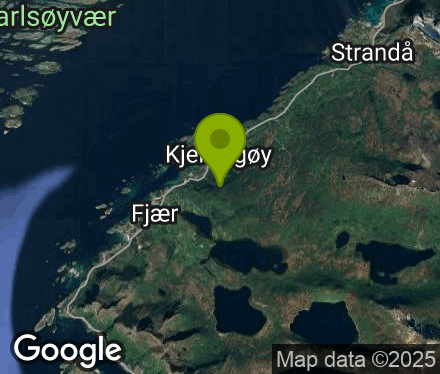
Nordland - Bodø - Kjerringøy
(Data fra flightlog.org - statistikk siste flyture)

Parker ved kapellet i Kjerringøy sentrum. Følg merket tursti til toppen, videre nordover ca 30 høydemeter ned. Landing på utmarksjordet ved kirka/handelsstedet. Nødlanding er avtalt tillatt på dyrket mark tilhørende Kjerringøy gård.

255 meters asl Høydeforskjell 250 meters

Kjenner du til denne spotten og har lyst å hjelpe Vindnå.no med oppdatert informasjon, sende inn dine endringsforslag her.

Kart

Værvarsel fra yr.no

 14:00  15:00  16:00  17:00  18:00  19:00  20:00  21:00  22:00  23:00  00:00  01:00  02:00  03:00  04:00  05:00  06:00  07:00  08:00  09:00 
yr.no
nedbør000.30.10.50.60.20.30.21.31.40.20.10.200.20.40.61.20.5
m/s 5.15.15.66.15.26.27.166.477.17.176.46.46.36.378.28.5
V
(251)
SV
(247)
SV
(245)
V
(252)
SV
(223)
SV
(211)
SV
(213)
SV
(232)
V
(251)
V
(250)
V
(251)
V
(265)
V
(272)
V
(274)
V
(270)
V
(272)
V
(252)
SV
(240)
SV
(242)
SV
(236)
C8.18.28.27.987.87.88.58.9999.19.198.68.78.68.89.19.2

Live værdata Auvika - Mjelle 13.3 km unna.

 14:20  14:10  14:00  13:50  13:40  13:30  13:20  13:10  13:00  12:50  12:40  12:30  12:20  12:10  12:00  11:00  10:00  09:00  08:00  07:00  06:00  05:00 
m/s 6.78.16.96.45.65.65.66.46.756.98.38.16.45.67.25.54.54.75.34.94.9
max 10.310.38.18.97.57.58.17.88.96.99.411.411.48.68.69.47.36.36.46.876.6
SV
(216)
S
(201)
SV
(211)
SV
(211)
SV
(204)
SV
(203)
SV
(204)
SV
(205)
SV
(209)
S
(200)
SV
(215)
SV
(214)
SV
(206)
SV
(225)
SV
(237)
SV
(222)
SV
(206)
SV
(211)
SV
(213)
SV
(209)
SV
(210)
SV
(203)
C6.66.76.26.66.76.56.36.56.56.56.56.26.66.66.36.46.265.85.85.95.9

Live værdata Myklebostad 19.8 km unna.

 14:20  14:10  14:00  13:50  13:40  13:30  13:20  13:10  13:00  12:50  12:40  12:30  12:20  12:10  12:00  11:00  10:00  09:00  08:00  07:00  06:00  05:00 
m/s 000000.9000.403.64.54.53.62.732.71.921.22.11.5
---------- ---- --
--
--
--
--
--
--
--
--
--
--
SV
(244)
--
--
--
--
SV
(213)
--
--
SV
(207)
SV
(229)
SV
(229)
SV
(207)
SV
(238)
SV
(228)
SV
(225)
SV
(217)
S
(202)
SV
(222)
SV
(207)
SV
(207)
C8.38.38.38.38.38.37.87.87.88.38.38.37.88.38.37.97.77.37.2777.1

Live værdata Keiservarden 24.6 km unna.

 14:20  14:00  13:20  13:10  12:50  12:30  12:10  11:00  10:00  09:00 
m/s 0000000000
max 0000000000
N
(0)
N
(0)
N
(0)
N
(0)
N
(0)
N
(0)
N
(0)
N
(0)
N
(0)
N
(0)
C05.20005.3501.70

Live værdata BESTEMORENGA 25.3 km unna.

 14:20  14:10  14:00  13:50  13:40  13:30  13:20  13:10  13:00  12:50  12:40  12:30  12:20  12:10  12:00  11:00  10:00  09:00  08:00  07:00  06:00  05:00 
m/s 2.73.12.21.31.31.82.21.82.71.82.21.34.93.12.73.32.722.21.90.50.4
SV
(232)
S
(198)
N
(360)
SV
(220)
S
(188)
SV
(213)
SV
(207)
SV
(207)
S
(199)
S
(202)
S
(191)
S
(180)
S
(176)
S
(193)
SV
(229)
SV
(215)
SV
(208)
S
(201)
S
(190)
S
(200)
N
(14)
N
(346)
C7.87.27.27.27.27.27.27.27.27.27.27.27.27.27.27.26.96.56.15.75.65.6

Live værdata Rv 80 Bertnes 25.5 km unna.

 14:20  14:10  13:50  13:40  13:30  13:20  13:10  12:50  12:40  12:30  12:20  12:10  11:00  10:00  09:00  08:00  07:00  06:00  05:00 
m/s 2.83.42.32.32.32.92.22.42.23.34.34.24.122.20.81.41.31.1
max 5.16.34.8444.64.54.23.65.67.16.66.93.54.52.22.82.62.1
SV
(224)
SV
(232)
SV
(228)
SV
(233)
SV
(232)
SV
(229)
SV
(232)
SV
(229)
SV
(239)
SV
(236)
SV
(241)
SV
(235)
SV
(235)
SV
(222)
SV
(225)
SV
(235)
SV
(240)

(50)

(59)
C8.88.88.58.48.48.387.87.77.67.57.887.77.26.76.55.95.9

Live værdata Rv 80 Nordvika 26.0 km unna.

 14:20  14:10  13:50  13:40  13:30  13:20  13:10  12:50  12:40  12:30  12:20  12:10  11:00  10:00  09:00  08:00  07:00  06:00  05:00 
m/s 1.11.52.12.11.31.10.50.50.50.40.30.30.40.50.40.30.30.40.3
max 22.83.23.732.411.210.80.60.70.90.90.80.70.50.90.7

(143)
S
(176)
SV
(224)
SV
(220)
SV
(219)
S
(179)

(117)
V
(282)
S
(181)
Ø
(90)
N
(1)
N
(11)

(148)
S
(199)

(35)
NV
(326)

(41)

(66)
NV
(319)
C7.77.87.37.37.376.96.86.86.76.96.76.265.75.55.45.35.2