logo Vind Nå Kom igang Kontakt info Innstillinger Del

Balestrand, Buråsi paragliding spot

Ø

Vestland - Sogndal - Balestrand
(Data fra flightlog.org - statistikk siste flyture)

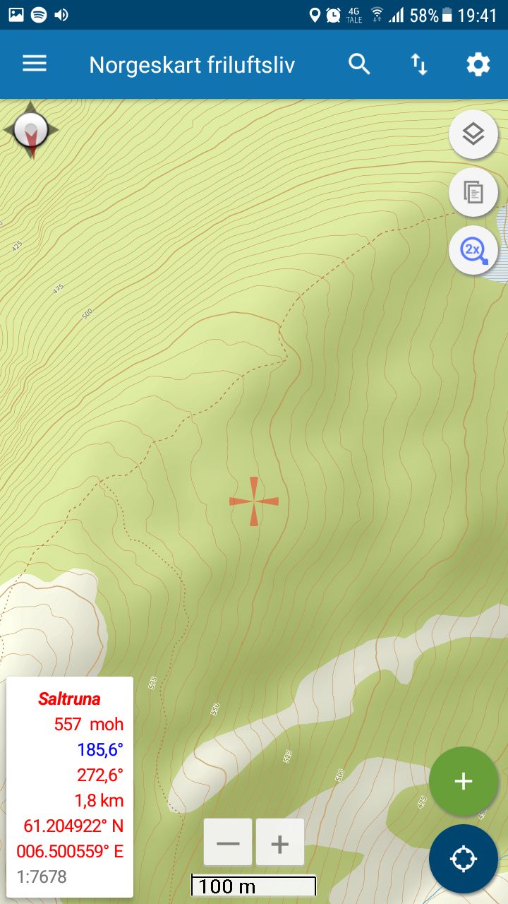
Føl merka sti til Buråsi (På veg til Raudmelen)
Follow marked trail towards Raudmelen. When at Buråsi, go a little to the east.

550 meters asl Høydeforskjell 450 meters

Kjenner du til denne spotten og har lyst å hjelpe Vindnå.no med oppdatert informasjon, sende inn dine endringsforslag her.

Bilde fra flightlog.org.

Kart

Værvarsel fra yr.no

 16:00  17:00  18:00  19:00  20:00  21:00  22:00  23:00  00:00  01:00  02:00  03:00  04:00  05:00  06:00  07:00  08:00  09:00  10:00  11:00 
yr.no
nedbør0000000000000.20.70.80.20000.3
m/s 3.64.65.15.15.55.24.84.44.94.94.64.44.344.46.35.34.64.73.9

(135)
V
(262)
V
(281)
V
(287)
V
(286)
NV
(298)

(134)

(132)

(134)
S
(159)

(149)

(128)
Ø
(87)
Ø
(94)
NV
(308)
V
(288)
V
(287)
NV
(326)
NV
(294)
V
(284)
C7.97.36.24.93.31.80.80.2000000.10.30.91.11.51.71.8

Live værdata BALESTRAND - BALE 1.5 km unna.

 16:00  15:00  14:00  13:00  12:00  11:00  10:00  09:00  08:00  07:00 
m/s 1.521.41.51.61.710.50.50.5
max 2.93.82.72.73.23.92.41.51.41.1
--------------------
--
--
--
--
--
--
--
--
--
--
--
--
--
--
--
--
--
--
--
--
C11.911.51110.79.99.3107.96.76

Live værdata VANGSNES 8.5 km unna.

 16:20  16:10  16:00  15:50  15:40  15:30  15:20  15:10  15:00  14:50  14:40  14:30  14:20  14:10  14:00  13:00  12:00  11:00  10:00  09:00  08:00  07:00 
m/s 5.14.76.25.64.94.95.36.25.75.254.84.44.44.54.33.92.72.63.64.24.5
max 8.27.49.17.98.17.97.68.68.47.47.36.76.56.67.26.56.44.345.26.26.7
SV
(231)
SV
(221)
SV
(225)
SV
(236)
SV
(236)
SV
(239)
SV
(234)
SV
(240)
SV
(238)
V
(250)
V
(251)
V
(248)
V
(250)
V
(249)
V
(249)
SV
(244)
V
(253)
V
(252)
V
(250)
SV
(247)
SV
(243)
SV
(240)
C10.410.510.110.310.510.610.29.9109.91010.19.910109.89.39.28.77.86.86.5

Live værdata Huksdalen 14.2 km unna.

 16:20  16:10  16:00  15:50  15:40  15:30  15:20  15:10  15:00  14:50  14:40  14:30  14:20  14:10  14:00  13:00  12:00  11:00  10:00  09:00  08:00  07:00 
m/s 1.12.52.81.70.84.43.13.63.90.61.71.93.62.54.21.72.41.510.50.80.4
max 2.25.34.22.83.16.94.45.64.41.43.92.84.43.95.83.14.432.31.21.71
SV
(223)
V
(251)
SV
(231)
V
(273)

(46)
V
(275)
V
(268)
V
(292)
V
(261)
SV
(203)
SV
(230)
V
(289)
V
(277)
V
(258)
V
(288)
SV
(234)
SV
(224)
Ø
(104)
S
(167)
V
(265)
V
(286)
Ø
(97)
C10.398.29.29.27.78.28.57.710.88.78.87.27.27.17.76.45.75.83.31.91.1

Live værdata NJØS 19.5 km unna.

 16:00  15:00  14:00  13:00  12:00  11:00  10:00  09:00  08:00  07:00 
m/s 1.62.32.72.92.72.62.112.41
max 4.34.74.74.84.24.73.644.74.1
SV
(238)
S
(193)
SV
(242)
SV
(208)
SV
(236)
SV
(214)
SV
(229)
V
(282)
N
(6)
N
(346)
C13.312.411.110.410.59.49.17.77.36.9

Live værdata Rv 5 Frudalen 25.5 km unna.

 16:20  16:10  16:00  15:50  15:40  15:30  15:20  15:10  15:00  14:50  14:40  14:30  14:20  14:10  14:00  13:00  12:00  11:00  10:00  09:00  08:00  07:00 
m/s 2.632.61.71.912.42.62.52222.22.42.32.31.92.41.61.61.40.5
max 5.64.74.23.43.133.43.52.93.13.94.23.543.943.63.32.42.62.31.5
V
(277)
V
(277)
V
(263)
V
(249)
V
(249)
S
(195)
S
(167)
S
(170)
S
(176)
S
(188)
S
(200)
SV
(216)
SV
(234)
SV
(239)
SV
(233)
V
(251)
V
(250)
SV
(209)
SV
(245)

(114)
Ø
(102)
N
(22)
C23.723.824.124.324.424.524.524.224.123.823.623.122.62221.220.219.3159.711.772.5

Live værdata Rv 13 Vikafjellet 26.2 km unna.

 16:10  16:00  15:50  15:40  15:30  15:20  15:10  15:00  14:50  14:40  14:30  14:20  14:10  14:00  13:00  12:00  11:00  10:00  09:00  08:00  07:00 
m/s 4.23.33.84.53.544.44.31.81.92.233.33.83.74.44.85.22.60.70.8
max 5.75.45.65.65.85.85.45.23.73.14.84.84.94.85.75.96.46.34.322.1
SV
(213)
SV
(218)
SV
(207)
SV
(212)
SV
(212)
SV
(206)
SV
(225)
SV
(237)
S
(200)
S
(189)
S
(190)
SV
(225)
SV
(225)
SV
(229)
SV
(218)
SV
(208)
SV
(208)
S
(202)
SV
(219)
S
(175)
NV
(319)
C3.63.73.73.73.6332.83.23.22.92.62.52.42.21.81.20.50-39.9-39.9