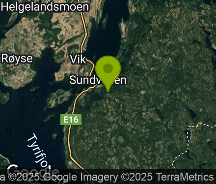
logo Vind Nå Kom igang Kontakt info Innstillinger

Sundvollen paragliding spot

NVNV

Viken - Hole - Krokkleiva
(Data fra flightlog.org - statistikk siste flyture)
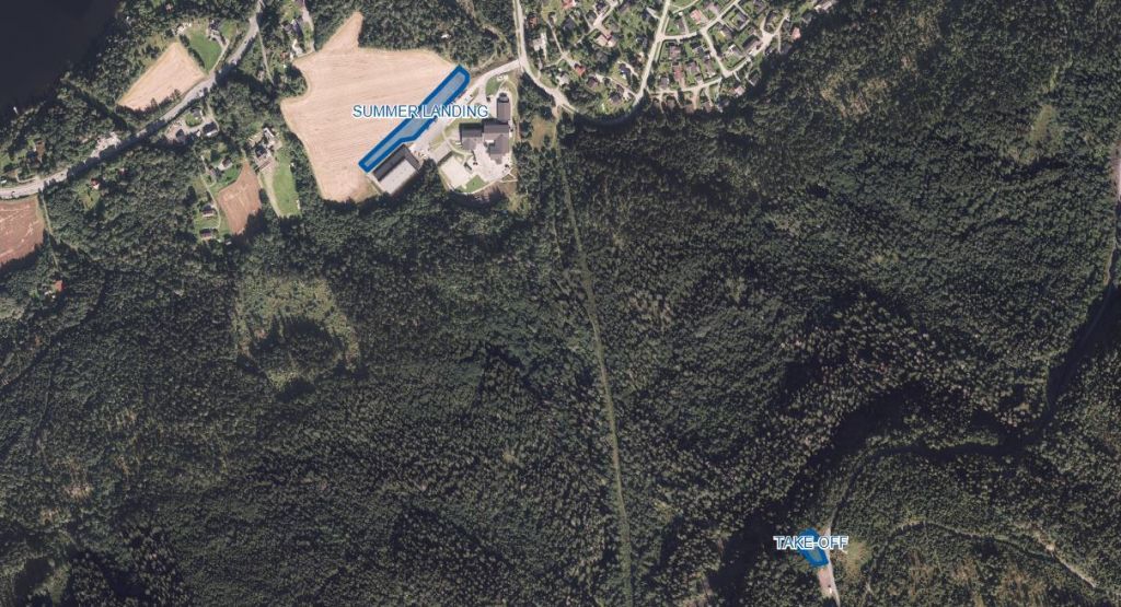
TAKE-OFF
Min. certification: PP2/SP2
Max. altitude (TMA): 914 m.a.s.l.
Take-off altitude: 390 m.a.s.l. (285 m top-to-bottom).
Orientation: WSW-NNE
Note: Expect turbulence in southerly winds.
Parking: Parking along the road is prohibited. Use only designated parking areas.
Road toll: Pay the road toll at each passage.
Unpacking: Unpack your glider in the parking area to avoid obstructing other pilots at take-off.
Aerial sporting box: The Sundvollen box can only be used when activated according to standard operating procedure.
Radio frequency (NLF): 154.175 MHz

LANDING
Landing: During growing season landings are limited to the designated area (see photo). Land as close to the field edge as possible. Always take the shortest way out of the field. Landing on the school’s parking lot is prohibited.
Note: Trees around the field creates turbulence in high winds. Be aware of children playing near by.
Parking: The school’s parking lot is only for loading and unloading. The road barrier could be closed without notice. Please park at Nedre Kleiva parking, abt. 100 meters past the school road.
Packing: Leave the landing field quickly. Pack your glider in the parking area.

390 meters asl Høydeforskjell 285 meters

Kjenner du til denne spotten og har lyst å hjelpe Vindnå.no med oppdatert informasjon, sende inn dine endringsforslag her.

Bilde fra flightlog.org.

Værvarsel fra yr.no

 22:00  23:00  00:00  01:00  02:00  03:00  04:00  05:00  06:00  07:00  08:00  09:00  10:00  11:00  12:00  13:00  14:00  15:00  16:00  17:00 
yr.no
nedbør000000000000.10.20.30.30.20000
m/s 4.74.854.94.64.64.34.24.243.63.73.73.53.63.43.12.21.51.4

(128)

(133)

(136)

(137)

(136)

(133)

(133)

(136)

(139)

(139)

(143)

(144)

(147)

(147)

(148)

(154)
S
(160)
S
(172)
SV
(222)
SV
(229)
C10.6109.58.77.87.26.76.46.46.46.677.98.68.99.910.613.214.715.4

Live værdata OPK Sundvollen 0 meter unna.

 22:50  22:40  22:30  22:20  22:10  22:00  21:50  21:40  21:30  21:20  21:10  21:00  20:50  20:40  20:30  20:20  20:10  20:00  19:00  18:00  17:00  16:00  15:00  14:00  13:00 
m/s 4.23.33.33.33.12.53.12.52.82.82.22.22.52.52.22.21.91.91.91.90.91.11.62.32
max 7.55.65.65.66.15.36.45.65.35.33.94.44.44.24.73.13.63.943.62.22.22.53.83.1
S
(160)

(149)

(145)

(138)

(135)

(154)

(142)

(135)

(122)

(155)

(135)

(144)

(150)

(144)

(134)

(157)
S
(161)
S
(160)

(147)

(139)
S
(187)
V
(287)
NV
(301)
NV
(302)
V
(291)
C8.78.78.78.78.78.78.58.58.59.7101010.210.210.711111111.912.716.116.314.114.212.9

Live værdata HØNEFOSS - HVERVEN 10.1 km unna.

 22:00  21:00  20:00  19:00  18:00  17:00  16:00  15:00  14:00  13:00 
m/s 2.62.12.531.61.41.51.22.52.1
max 5.44.24.453.63.444.14.95

(140)

(126)

(127)
Ø
(89)
NV
(294)
V
(261)
S
(159)
S
(165)
NV
(317)
NV
(334)
C1212.81414.715.516.917.3171514.3

Live værdata HØNEFOSS - HØYBY 13.2 km unna.

 22:50  22:40  22:30  22:20  22:10  22:00  21:50  21:40  21:30  21:20  21:10  21:00  20:50  20:40  20:30  20:20  20:10  20:00  19:00  18:00  17:00  16:00  15:00  14:00  13:00 
m/s 2.52.11.30.91.71.81.61.71.91.82.122.122.62.52.6221.42.51.61.62.13.1
max 4.84.13.73.73.74.14.14.14.14.35.15.25.25.25.25.25.24.84.44.553.744.75.5
S
(162)
S
(165)
S
(173)

(154)
S
(160)
S
(163)

(156)
S
(163)

(157)
S
(161)
S
(160)

(155)

(149)

(143)

(138)

(141)

(137)

(140)

(129)
N
(22)
SV
(233)

(31)
S
(158)

(47)
N
(19)

Live værdata OPK Solfjellstua 15.2 km unna.

 22:50  22:40  22:30  22:20  22:10  22:00  21:50  21:40  21:30  21:20  21:10  21:00  20:50  20:40  20:30  20:20  20:10  20:00  19:00  18:00  17:00  16:00  15:00  14:00  13:00 
m/s 3.63.11.91.73.32.21.40.81.71.12.21.70.80.80.60.801.72.21.81.70.81.50.10.7
max 54.753.64.43.93.12.53.31.93.64.42.21.73.11.70.83.33.83.43.51.62.60.91.2
Ø
(107)

(118)
Ø
(93)
Ø
(82)
Ø
(76)
Ø
(73)
Ø
(82)
Ø
(71)
Ø
(100)
Ø
(96)
Ø
(83)
Ø
(88)
Ø
(92)
Ø
(88)
Ø
(78)
Ø
(109)
Ø
(95)
Ø
(99)
Ø
(106)
Ø
(70)
Ø
(74)

(150)

(153)
S
(179)
S
(180)
C9.79.79.79.510.210.210.510.510.510.710.710.71111.211.511.511.711.712.312.814.115.415.917.114.9

Live værdata TRYVANNSHØGDA 20.7 km unna.

 22:50  22:40  22:30  22:20  22:10  22:00  21:50  21:40  21:30  21:20  21:10  21:00  20:50  20:40  20:30  20:20  20:10  20:00  19:00  18:00  17:00  16:00  15:00  14:00  13:00 
m/s 4.24.63.93.43.43.63.7444.34.24.14.13.84.13.84.24.343.84.12.92.21.72.2
max 6.15.64.94.54.34.44.8555.15.455.34.6555.35.45.35.764.94.13.73.9

(148)

(141)

(132)

(129)

(122)

(124)

(120)

(118)

(118)

(120)

(129)

(127)

(124)

(117)
Ø
(110)

(115)
Ø
(111)
Ø
(107)
Ø
(99)
Ø
(90)
Ø
(83)

(41)
Ø
(86)

(62)

(65)

Live værdata Opsahlåsen DROP 22.5 km unna.

 22:50  22:40  22:30  22:20  22:10  22:00  21:50  21:40  21:30  21:20  21:10  21:00  20:50  20:40  20:30  20:20  20:10  20:00  19:00  18:00  17:00  16:00  15:00  14:00  13:00 
m/s 3.13.11.71.72.50.60.61.92.21.73.12.51.91.91.92.52.51.92.42.11.20.70.611.5
max 3.95.32.82.53.31.71.43.33.13.14.73.33.93.33.64.24.23.34.23.72.21.51.51.82.9
S
(194)
S
(181)

(136)
Ø
(99)
Ø
(86)
Ø
(109)

(41)

(118)
Ø
(90)
Ø
(106)
Ø
(81)
Ø
(84)
Ø
(72)
Ø
(76)
Ø
(105)
Ø
(81)
Ø
(86)
Ø
(71)

(63)

(49)

(52)
N
(344)
N
(340)
N
(341)
N
(360)
C1212.212.512.712.712.712.712.7131313.213.513.713.71414.214.214.215.616.219.420.220.422.420.7